Crafting a Storm Surge and Hurricane Risk Rating for Coastal Properties

Crafting a Storm Surge and Hurricane Risk Rating for Coastal Properties

In an era where climate change is intensifying the frequency and severity of storms and hurricanes, especially in coastal regions, understanding and quantifying the associated risks is critical.

According to the National Geographic Society, a storm surge is a rise in sea level that occurs during tropical cyclones, which are intense storms also known as typhoons or hurricanes.

The storms produce strong winds that push the water into shore which can lead to flooding and pose a real threat in coastal regions.

To help understand these risks, a Storm Surge and Hurricane Risk Rating score can provide property owners, developers, real estate agents, insurers, urban planners, local governments, buyers and investors with a clear picture of a property’s vulnerability to these natural disasters.

These stakeholders will be conducting their own necessary research, and a risk rating system can offer an indicative metric to guide their decisions.

Why is a Storm Surge and Hurricane Risk Rating Important?

Understanding storm surge and hurricane risks is crucial for building a resilient society.

Natural catastrophes pose significant challenges, and quantifying these risks can aid in better preparation and prompt responses.

Strengthening homes and incentivising homeowners to invest in property fortification can reduce potential losses. Accurate risk assessments and reliable data can allow insurers to offer discounts for mitigation actions, enhance home resale values, and reveal the increased costs to mortgage issuers due to natural disasters.

Achieving resilience relies on expert understanding of the real estate ecosystem and the benefits of informed mitigation strategies.

Steps to build a Storm Surge and Hurricane Risk Rating

1. Defining scoring criteria and scale

The foundation of a risk rating system is a clear and understandable scale, such as 1 to 10, with each number representing a different level of risk.

Establishing specific criteria for assessment is also essential for a well-rounded evaluation.

2. Key factors to consider

Several factors contribute significantly to a property’s risk from storm surges and hurricanes:

Proximity to coast


  • Proximity to Coastline: The closer a property is to the coastline, the higher the risk of storm surge impacts.
  • Elevation and Topography: Properties at higher elevations or with certain topographical features may have reduced risk.
  • Historical Data: Analysing past hurricane and storm surge incidents from historical weather databases and local government records can provide critical insights into potential future risks.
  • Local Climate Trends: Understanding the local weather patterns can help predict the likelihood of storms.
Natural barriers
  • Flood Zone Designation: Properties in designated flood zones face a heightened risk. Flood risk information is generally available from Local Councils.
  • Building Design and Materials: Construction that is designed to be resilient against high winds and flooding can mitigate risk.
  • Infrastructure and Preparedness: Robust local infrastructure and emergency plans can play a vital role in risk reduction.
  • Natural Barriers: The presence of natural features, such as dunes or wetlands that can absorb storm impacts, reduces risk.
  • Regional Planning: Effective community and regional planning and zoning can mitigate potential damage. Consult local zoning laws and development plans for more property-specific.

3. Assigning weights to each factor

Assigning appropriate weights to each of the above factors based on its impact on overall risk ensures that the score accurately reflects the property’s vulnerability.

Use expert consultations and statistical analysis to determine appropriate weights, and adjust weights based on real-world data and expert feedback.

4. Data collection and analysis

Gathering and analysing data, including GIS mapping, climate records and historical event data, is crucial to assigning accurate sub-scores for each criterion. Cross-referencing multiple sources will ensure data accuracy and statistical software can be used for thorough analysis.

5. Calculating the overall score

By aggregating these sub-scores, considering their respective weights, we arrive at a comprehensive risk rating for each property. Using a formula or algorithm will ensure consistency in calculations. Further validating the scoring system with sample properties will help improve accuracy.

6. Validation and adjustment

It’s vital to validate and adjust the rating system against historical data and expert analysis to ensure its reliability and accuracy. Regularly review and update the criteria and weights based on new data.

Checklist

7. Providing risk mitigation recommendations

Along with the risk score, offering advice on how to reduce a property’s vulnerability to storm surges and hurricanes can be highly beneficial. Suggestions such as upgrading building materials, improving drainage systems or investing in flood barriers can form a checklist of actionable steps to reduce a property’s vulnerability.

8. Regular updates and re-evaluations

Continuously updating the risk rating system to reflect environmental changes, infrastructure developments and updated data is crucial. This includes regular reviews, incorporating new data and tech advancements can improve the risk rating system. 

Building Resilience with Accurate Risk Ratings

Stakeholders can create a robust and reliable risk rating system that enhances safety and preparedness in coastal areas.

A well-developed Storm Surge and Hurricane Risk Rating can provide essential information for making educated decisions about property development, insurance and risk management.

As the world grapples with the increasing challenges of climate change, these tools become ever more critical in our collective efforts to build resilient communities.

Subscribe to our newsletter

Subscribe to receive the latest blogs and data listings direct to your inbox.

Read more blogs from The Proptech Cloud

Crafting a Storm Surge and Hurricane Risk Rating for Coastal Properties

A high-level approach to developing a storm surge and hurricane risk rating system to guide stakeholders with a vested interest in coastal properties.

How Proptech Is Revolutionising Real Estate

Proptech is the dynamic intersection of property and technology, and it’s reshaping real estate. And there’s still a huge potential for growth.

What is the Australian Statistical Geography Standard (ASGS)?

The ASGS is used to better understand where people live and how communities are formed.

How to Incorporate Mesh Blocks into Datasets

Mesh blocks can enhance the precision and relevance of geospatial and proptech analyses. Here are some tips and steps to incorporate mesh blocks into datasets.

Australia’s Migration Trends: Where Are People Moving To?

This detailed visual analysis for Australia’s major capital cities breaks down how net migration trends are evolving across different regions.

Could a Revamp of Australian Property Planning Rules Solve Some of Australia’s Housing Issues?

Could a Revamp of Australian Property Planning Rules Solve Some of Australia’s Housing Issues?

Rising property prices and high costs of living means the Australian dream of home ownership is slipping further and further away for many. Could an overhaul of Australian property planning rules offer a solution?

In recent discussions during a heated ABC Q+A debate on Homeownership, Homelessness & Housing supply, the Australian dream of homeownership has taken centre stage again, unveiling a crisis that grips not just potential homeowners but extends its grasp towards the homeless and vulnerable communities across the nation.

Even those “fortunate” enough to have purchased property are feeling significant interest rate stress as cost-of-living soars in recent times. Renters are experiencing rent hikes and dealing with historically low vacancy rates.

Australia’s housing issues in the spotlight

“Fundamentally, the problem is that we’re not building enough homes,” Mr Leigh, the Assistant Minister for Competition, Charities and Treasury, told Q+A.

It’s clear that Australia requires millions more homes to meet current demand but also accommodate future population growth.

However, as it stands, governments are finding it challenging to meet their own targets.

The debate, and followed up by The Sydney Morning Herald article Do planning rules really affect house prices? The answer is clear, has cast a spotlight on a host of interconnected factors contributing to this issue.

At the heart of the matter are planning and zoning rules, which, contrary to some beliefs, significantly influence housing prices and supply. This is a contentious point, highlighted by the disagreement between Max Chandler-Mather, Greens Spokesperson on Housing & Homelessness, and Dan McKenna, CEO of Nightingale Housing, pointing to a deeper complexity within the debate.

While Shadow Assistant Minister for Home Ownership, Senator Andrew Bragg’s remarks on construction industry, skills shortage and migration underscores the multifaceted approach needed to address the crisis.

This crisis reflects broader societal issues—including a shortage in construction and trades to debates on policy, immigration, and infrastructure development.

The challenges extend to financial mechanisms of owning a home, with strategies like tapping into superannuation funds or adopting shared equity schemes considered as possible solutions (which have their own implications).

As housing prices in some states soar to record levels and impact housing affordability, the dream slips further away for many, with rising homelessness a sign of a deepening emergency.

The conversation also touched on regulatory measures like controlling rent increases and revisiting the impacts of capital gains tax and tax concessions, such as negative gearing, which has been identified as contributing factors in the price hikes over the last few decades.

A possible solution to the housing crisis

Looking beyond our shores for solutions, it’s clear that this is not an issue unique to Australia.

International examples offer alternative paths forward and suggest a re-evaluation of property planning rules.

But first, we need to understand our current property planning rules.

Captured and represented by Archistar, Australian Property Planning Rules for Land Use could provide crucial insights into land use and, potentially, relief to the crisis. The data, available via the Snowflake Marketplace, details current land use zoning applied across the nation with geospatial representation. The use of that data can help us to understand where we currently stand and offer possible solutions when variables are tweaked, such as housing density.

Another challenge in solving the housing affordability problem in Australia, and globally for that matter, is the accessibility of data. 

Archistar is helping to break down these barriers by collating national datasets for planning rules that can be easily accessed and analysed using Snowflake’s Data Platform.

The way forward

As we negotiate this national emergency, it becomes increasingly evident that a multifaceted and inclusive approach is essential.

Engaging in open discussions, exploring innovative housing policies, and reconsidering the frameworks which our housing market operates could pave the way towards a more equitable future.

The dream of homeownership, safeguarding against homelessness, and the creation of sustainable communities demand it.

Australian Property Planning Rules for Land Use

Access Archistar’s Australian Property Planning Rules and understand zoning designations and regulations across the nation.

Subscribe to our newsletter

Subscribe to receive the latest blogs and data listings direct to your inbox.

Read more blogs from The Proptech Cloud

Crafting a Storm Surge and Hurricane Risk Rating for Coastal Properties

A high-level approach to developing a storm surge and hurricane risk rating system to guide stakeholders with a vested interest in coastal properties.

How Proptech Is Revolutionising Real Estate

Proptech is the dynamic intersection of property and technology, and it’s reshaping real estate. And there’s still a huge potential for growth.

What is the Australian Statistical Geography Standard (ASGS)?

The ASGS is used to better understand where people live and how communities are formed.

How to Incorporate Mesh Blocks into Datasets

Mesh blocks can enhance the precision and relevance of geospatial and proptech analyses. Here are some tips and steps to incorporate mesh blocks into datasets.

Australia’s Migration Trends: Where Are People Moving To?

This detailed visual analysis for Australia’s major capital cities breaks down how net migration trends are evolving across different regions.

Top Real Estate Technology Global Events

Top Real Estate Technology Global Events

As the real estate industry continues to evolve at a rapid pace, staying abreast of the latest trends, technologies, and innovations is crucial for professionals seeking to leverage the full potential of real estate technology and proptech.

For anyone in property and real estate, attending global proptech events offers a chance to integrate into the wider real estate technology industry. 

Top 3 reasons why these events are valuable

1. Networking, learnings and potential partnerships

A diverse mix of professionals allow for broader networking opportunities than what your local market may offer. Particularly in overseas markets where the proptech industry may be more mature or advanced compared with your local region, these events allow you to connect with leaders, potential customers, and collaborators who might offer valuable learnings, insights to trends and new technology, alternative business models or a global perspective into the market and competition. These events could offer a platform for gaining feedback and validation, or even to identify and recruit talent.

2. Brand visibility and marketing

Participation at these events may significantly increase a business’ visibility within the global industry; even more so if you attend as a speaker or exhibitor. An effective platform to showcase innovations, solutions, and success stories to a targeted audience, high visibility can enhance brand recognition, attract leads or other marketing opportunities.

3. Investor engagement

Often attended by venture capitalists, angel investors, and other financial backers actively seeking to invest in promising startups, these events can offer potential pitching sessions, one-on-one meetings, and informal networking opportunities. 

Global Real Estate Technology and Proptech events

2024 delivers a range of global events dedicated to real estate technology and proptech, offering plenty of opportunities for learning, networking, and growth. Varying from conferences to interactive expos, these events bring together thought leaders, innovators, and practitioners from around the world. Here is our round-up of top global events:

Event

Description

Location

Dates

RETCON 2024Real Estate’s Leading Technology & Innovation ConferenceNew York, USA1-3 April
PropTech SummitPropTech Summit is the new trade fair and conference for the PropTech industryHamburg, Germany10-11 April
CRETech LondonThe World’s Leading Built World Innovation and
Sustainability Conference Series
London, UK8-9 May
PropTech Symposium DenmarkExciting debates, startup showcases, and insights from international thought leadersCopenhagen, Denmark13 May
Future of Construction SummitThe annual gathering for the people and companies redefining Australia’s construction industryBrisbane, Australia14-15 May
Property Technology ConfexA Digital & Sustainable Built Environment –
Investing, Selling, Managing and Operating
Dubai, UAE3-4 June
Proptech ViennaThe networking conference on innovation, technology and sustainability in the international real estate industry, connecting tech and real estate experts with startups, scaleups, investors, business angels, VCs and industry associations.Vienna, Austria13 June
Australian Proptech SummitProptech solutions for Australia’s new commercial and residential realitySydney, Australia30 July – 1 August
Inman ConnectThrough immersive experiences, innovative formats, and an unparalleled lineup of speakers, this gathering becomes more than a conference — it becomes a collaborative force shaping the future of our industrLas Vegas, USA30 July – 1 August
iOi Summit by NARPropTech leaders and futurists, investors, and forward-thinking real estate professionals come together to fuel the future of the industry.Chicago, USA28-29 August
PropTech ConnectEurope’s largest proptech  eventLondon, UK4-5 September
REAL PropTech ConferenceGermany’s most important conference on PropTech, digitalisation and transformation of the construction and real estate industryFrankfurt am Main, Germany4-5 September
BlueprintThe premier event for industry executives, real estate & construction tech startups, and VCs.Las Vegas, USA17-19 September
Expo Real 2024Expo Real is the most important trade fair for the real estate industry and offers a comprehensive overview of developments, topics, innovations and solutions in the real estate industry.Dubai, UAE7-9 October
Proptech Forum 2024An event to unite proptech founders and teams collaborating on the future of the industry.Sydney, Australia17 October
Urban Tech ForwardUrban Tech Forward aims to accelerate the development of net-zero cities. Designed to rethink spaces where people live and work – through the prism of decarbonisation and resilience – it brings together urban tech innovators, VCs, real estate developers, policy-makers and most prominent entrepreneurs to shift the way we build and make real progress on achieving a zero-carbon future.Warsaw, Poland25-26 October
CRETech New YorkThe World’s Leading Built World Innovation and
Sustainability Conference Series
New York, USA13-14 November
Home apti AwardThe apti award recognises the most innovative Tech provider and startups in the international Real Estate sector. Both national and international PropTechs have the opportunity to apply in the categories.Palais Berg, Austria14 November

Other Considerations

Other than factoring in the cost and time associated with traveling and attending these global events, consider the relevance and quality, because not all events are created equal.

Check for alignment and relevance with your niche and strategic focus.

And lastly, with the growing range of digital alternatives, consider whether virtual events can offer you similar benefits.


Subscribe to our newsletter

Subscribe to receive the latest blogs and data listings direct to your inbox.

Read more blogs from The Proptech Cloud

Crafting a Storm Surge and Hurricane Risk Rating for Coastal Properties

A high-level approach to developing a storm surge and hurricane risk rating system to guide stakeholders with a vested interest in coastal properties.

How Proptech Is Revolutionising Real Estate

Proptech is the dynamic intersection of property and technology, and it’s reshaping real estate. And there’s still a huge potential for growth.

What is the Australian Statistical Geography Standard (ASGS)?

The ASGS is used to better understand where people live and how communities are formed.

How to Incorporate Mesh Blocks into Datasets

Mesh blocks can enhance the precision and relevance of geospatial and proptech analyses. Here are some tips and steps to incorporate mesh blocks into datasets.

Australia’s Migration Trends: Where Are People Moving To?

This detailed visual analysis for Australia’s major capital cities breaks down how net migration trends are evolving across different regions.

What Are Mesh Blocks & How Are They Used in Real Estate

What Are Mesh Blocks & How Are They Used in Real Estate

What are Mesh Blocks?

As defined by Australian Bureau of Statistics (ABS), mesh blocks are the smallest geographical area of the Australian Statistical Geography Standard (ASGS) and ABS’s classification of Australia into a hierarchy of statistical areas.

Mesh Blocks are essentially a set of geographic boundaries designed to segment Australia into very small areas. These boundaries are used to apply a systematic grid over the entire country, dividing it into tiny sections called Mesh Blocks.

Each Mesh Block is a polygon that outlines a specific piece of land, which can range from a single block in a city to a vast, sparsely populated area in the countryside.

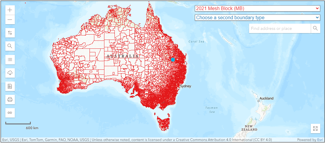
In 2021, the ABS reported 368,286 Mesh Blocks covering the whole of Australia without gaps or overlaps.

Mesh Blocks covering the whole of Australia. Source: ABS Maps


Mesh Block design

Mesh Blocks for the current ASGS Edition 3 are designed according to a standard set of design criteria first developed for ASGS 2011.

Most Mesh Blocks are designed to contain 30 to 60 dwellings, although some low dwelling count Mesh Blocks exist. They are permitted in order to account for other design criteria.

The reasons for the minimum dwelling count of Mesh Blocks is so they’re small enough to aggregate to a wide range of areas, allow comparisons between geographic regions but also prevent accidentally exposing confidential information of individuals or businesses.


Mesh Block changes

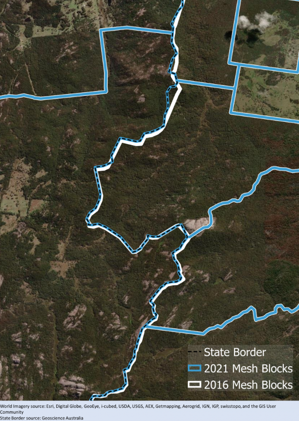
Mesh Blocks are updated (or redesigned) every 5 years to stay relevant.

Mesh Blocks for the current ASGS Edition 3 was redesigned to ensure it still meets the design criteria first developed for ASGS 2011 and reflects the growth and change in Australia’s population, economy and infrastructure.

Mesh Block Changes

Example of Mesh Block change along the border of Queensland and New South Wales. Source: Australian Bureau of Statistics

How are Mesh Blocks created?

Each Mesh Block is assigned a unique numerical code or identifier. This code is used to reference the Mesh Block in statistical databases and geographic information systems (GIS).

The format of the code can vary but often includes digits that signify hierarchical levels of geography.

In Australia, Mesh Block identifiers are 11-digit codes.

The 11-digit Mesh Block code comprises: State and Territory identifier (1 digit), and a Mesh Block identifier (10 digits).

How are Mesh Blocks used?

The ABS does not and cannot provide detailed segmentation data (Census data) that can be directly connected to individuals or businesses. Instead, they provide anonymised and aggregated data against geographic areas. Mesh Blocks are the smallest geographic area that the ABS provide statistics against, so it offers population and dwelling counts at a hyper-local level – this is particularly useful for Census analysis.

These geographic boundaries allow for the aggregation of data from individual Mesh Blocks into larger geographic units, such as suburbs, towns, cities, and regions. This hierarchical structuring makes it possible to analyse data at various levels, from very detailed local information to broader regional or national trends.

Most businesses, including proptechs, looking to augment their analysis with population segmentation data will adopt Mesh Blocks as their default level geographic unit to gain the highest level of accuracy. The popularity of Mesh Blocks mean many businesses will use it for geographic statistics regardless of whether or not the Census data is being leveraged.

What role do Mesh Blocks play in proptech?

Mesh Blocks play a vital role in Proptech, geospatial data, and the real estate industry in Australia. Some example uses include:

Granular geographical data

Since Mesh Blocks are the smallest geographical units, providing a granular level of detail in geographic data, its precision is valuable for analysing real estate trends at a hyper-local level.

Accurate small area statistics

Mesh Blocks are designed to fulfill the need for accurate small area statistics. In Proptech, having precise data at this level is instrumental for understanding localised property markets, demographics, and trends.

Spatial mapping and analysis

Geospatial data, including Mesh Blocks, facilitates spatial mapping and analysis. Proptech platforms can leverage this data to visualise and analyse property-related information, helping users make more informed decisions based on geographical insights.

Enhanced property valuation

Proptech applications can utilise Mesh Blocks to refine property valuation models. The data on dwellings and residents at this level allows for a more nuanced understanding of property values, considering localised factors.

Land use identification

Mesh blocks broadly identify land use, such as residential, commercial, industrial, parkland, and so forth. Land use information is valuable for proptechs involved in property development, urban planning, and investment strategies.

Targeted marketing and outreach

Proptech businesses can use Mesh Block data to tailor marketing and outreach strategies to specific geographical areas. Understanding the demographics and dwelling counts at this level allows for targeted and effective location-based campaigns.

Census-driven insights

The inclusion of Census data within Mesh Blocks, such as the count of usual residents and dwelling types, provides proptech platforms with up-to-date demographic information. This can aid market analysis, customer profiling, and investment strategies.

Integration with digital boundary files

The availability of Mesh Block boundaries in digital boundary files enhances their usability in Proptech applications. These files can be readily integrated into geospatial systems, making it easier for developers and analysts to work with this geographical data.

The foundational building blocks in real estate

Mesh Blocks are foundational building blocks for geospatial and proptech applications, providing granularity and accuracy for understanding local real estate markets, demographics and land use.

To aid proptechs, The Proptech Cloud offers its Geography – Boundaries & Insights dataset which includes all mesh blocks and their spatial areas for analysis and location-based visualisation of statistics.

The integration of this important information can enhance the precision and relevance of analyses within the proptech and real estate sectors. Read our following blog to learn how to incorporate Mesh Blocks into datasets.

How to Incorporate Mesh Blocks into Datasets

Incorporating mesh blocks into datasets involves several steps to ensure seamless integration and effective utilisation of geographical information. Here’s a guide on how to incorporate mesh blocks into datasets.

Subscribe to our newsletter

Subscribe to receive the latest blogs and data listings direct to your inbox.

Read more blogs from The Proptech Cloud

Crafting a Storm Surge and Hurricane Risk Rating for Coastal Properties

A high-level approach to developing a storm surge and hurricane risk rating system to guide stakeholders with a vested interest in coastal properties.

How Proptech Is Revolutionising Real Estate

Proptech is the dynamic intersection of property and technology, and it’s reshaping real estate. And there’s still a huge potential for growth.

What is the Australian Statistical Geography Standard (ASGS)?

The ASGS is used to better understand where people live and how communities are formed.

How to Incorporate Mesh Blocks into Datasets

Mesh blocks can enhance the precision and relevance of geospatial and proptech analyses. Here are some tips and steps to incorporate mesh blocks into datasets.

Australia’s Migration Trends: Where Are People Moving To?

This detailed visual analysis for Australia’s major capital cities breaks down how net migration trends are evolving across different regions.

Understanding Auction Clearance Rates: Why Do Calculations Differ?

Understanding Auction Clearance Rates: Why Do Calculations Differ?

Auction clearance rates can serve as a barometer of Australia’s real estate market strength, particularly across its major cities.

These rates are generally a superficial gauge of market strength, because private treaty is still the most common means of property sale in some cities. Nevertheless, property predictions can be drawn when auction clearance rates are analysed alongside other factors and data points.

Clearance rates for Australia’s major real estate markets can be helpful for proptechs who leverage data, analytics, and technology to advance various aspects of the real estate industry.

What Is An Auction Clearance Rate?

The auction clearance rate typically represents the percentage of properties that sold on its advertised auction date in a specific market versus the number of properties that didn’t sell during a particular time frame (typically a week or month).

How Are Auction Clearance Rates Calculated?

There are variations in how clearance rates are calculated and reported, so it’s important to consider this and understand your data provider’s calculations. The variance in calculations means these metrics offer different views and are not interchangeable.


Variations to the Calculation

Calculation

Calculation (%)

Basic calculationPercentage of properties sold on auction date during a particular period (week or month)Basic calculation of auction clearance rates
Includes properties sold prior to and during auctionPercentage of properties sold prior to plus on auction date during a particular period (week or month)Basic Calculation + Properties sold prior to auction
Includes properties sold prior to, during and after auctionPercentage of properties sold prior to auction plus on auction date plus after auction date during a particular period (week or month)Sold prior + at + after auction Calculation 


What Do Auction Clearance Rates Tell Us?

Auction clearance rates are a crucial market indicator of real estate activity by gauging the numbers of buyers and sellers in a specific market during a certain time frame.

Generally, higher auction clearance rates indicate a higher buyer demand for property in that market, limited supply of available properties and/or with an increased likelihood of rising price, i.e. a hot market for sellers.

Conversely, low auction clearance rates indicates weak buyer demand, possible over-supply of properties and chance of reduced prices which is more favourable to buyers.

In Sydney and Melbourne, a clearance rate above 70% signals a seller’s market, below 60% suggests a buyer’s market, and 60-70% indicates balance.

But the true significance of auction clearance rates lies in its contextual analysis alongside factors such as listing numbers, days on market, withdrawn auctions, fluctuations and regional disparities.

By tracking these rates alongside additional metrics, analysts can anticipate market direction, and measure buyer and seller confidence.

Where Can I Find Clearance Rates For Australia’s Capital Cities?

Auction clearance rates in Australia are reported on a weekly basis.

Some organisations collect data from sales agents and aggregate the data by city and region, such as:

Some news outlets, auction houses and real estate agencies may also publish auction clearance rates for specific regions. Industry reports and analyses related to real estate may also compile this data to provide a comprehensive view into trends.

How Important Are Auction Clearance Rates?

For anyone involved in or impacted by the real estate market, auction clearance rates are an important indicator of demand levels, market sentiment, and potential shifts in property values. But when comparing available data, its crucial to understand the methodology behind the calculations of auction clearance rates.

Auction clearance rates should be used as part of a comprehensive analysis alongside other property data, localised research, and broader market factors. While auction clearance rates offer valuable insights into the direction of the property market, they are just one of many factors to consider, and a holistic approach incorporating various data points is recommended for a thorough understanding of market conditions.

How Might Auction Clearance Rates Be Used By Proptechs?

While not exhaustive, these are a few examples of how auction clearance rates might be used by proptechs and businesses working with real estate data.

  • By analysing clearance rates and buyer demand, price trends can be used to gauge competitiveness of the market. These could all be incorporated into tool development or software development, it could be used to optimise platform features, or to guide content creation to engage users.
  • Combining this information with localised data for property investment, integrating clearance rate data into risk assessment models could allow for more informed investment decisions.
  • Property valuation models could be enhanced with the use of real-time clearance rate data which provides more accurate and dynamic property valuations in areas of high auction activity.

Subscribe to our newsletter

Subscribe to receive the latest blogs and data listings direct to your inbox.

Read more blogs from The Proptech Cloud

Crafting a Storm Surge and Hurricane Risk Rating for Coastal Properties

A high-level approach to developing a storm surge and hurricane risk rating system to guide stakeholders with a vested interest in coastal properties.

How Proptech Is Revolutionising Real Estate

Proptech is the dynamic intersection of property and technology, and it’s reshaping real estate. And there’s still a huge potential for growth.

What is the Australian Statistical Geography Standard (ASGS)?

The ASGS is used to better understand where people live and how communities are formed.

How to Incorporate Mesh Blocks into Datasets

Mesh blocks can enhance the precision and relevance of geospatial and proptech analyses. Here are some tips and steps to incorporate mesh blocks into datasets.

Australia’s Migration Trends: Where Are People Moving To?

This detailed visual analysis for Australia’s major capital cities breaks down how net migration trends are evolving across different regions.