How to Incorporate Mesh Blocks into Datasets

How to Incorporate Mesh Blocks into Datasets

Mesh Blocks in real estate and proptech applications

Mesh Blocks are useful for geospatial and proptech applications, providing granularity and accuracy for understanding local real estate markets, demographics and land use.

The integration of Mesh Blocks into datasets can enhance the precision and relevance of analyses within the proptech and real estate sectors.

Useful in geospatial data and census analyses, embedding Mesh Blocks into digital boundaries enhances their usability in various applications.

We will cover the steps to incorporate mesh blocks into data sets below.

What are Mesh Blocks and how are they used in real estate?

Mesh Blocks are foundational building blocks for geospatial and proptech applications, providing granularity and accuracy for understanding local real estate markets, demographics and land use.

How to incorporate Mesh Blocks into datasets

Incorporating Mesh Block into datasets involves several steps to ensure seamless integration and effective utilisation of geographical information. Here’s a guide on how to incorporate Mesh Blocks into datasets:

Step 1: Data Collection

Gather relevant data that aligns with Mesh Blocks.

This may include demographic information, property values, land use details, or any other dataset that can be associated with specific geographical areas.


Step 2: Download Mesh Block Boundaries

Mesh Block boundary files can be downloaded from authoritative sources, such as the Australian Bureau of Statistics (ABS) or relevant statistical agencies.

For ease, The Proptech Cloud has a free comprehensive dataset Geography – Boundaries & Insights – Australia ready for access and immediate use.

Geography – Boundaries & Insights – Australia

This free dataset from The Proptech Cloud is available for seamless access from Snowflake Marketplace.

Step 3: Geospatial Data Processing

Use Geographic Information System (GIS) software or programming libraries (e.g., Python with geospatial libraries like GeoPandas) to process and manipulate the mesh block boundaries.

Tip:

Geographical boundaries can be imported using Python libraries including Geopandas and shapely.

Many data warehouses including Snowflake, BigQuery and PostgreSQL have in-built geospatial functionality to allow for the processing of geospatial data.

QGIS – Loading in Geospatial files in QGIS

1. From the toolbar at the top of the page click Layer > Add Layer > Add Vector Layer

2. Make sure the Source Type is clicked to File

3. Load in the Source Data by using the three dots button at the side of the Vector Dataset(s) toolbar
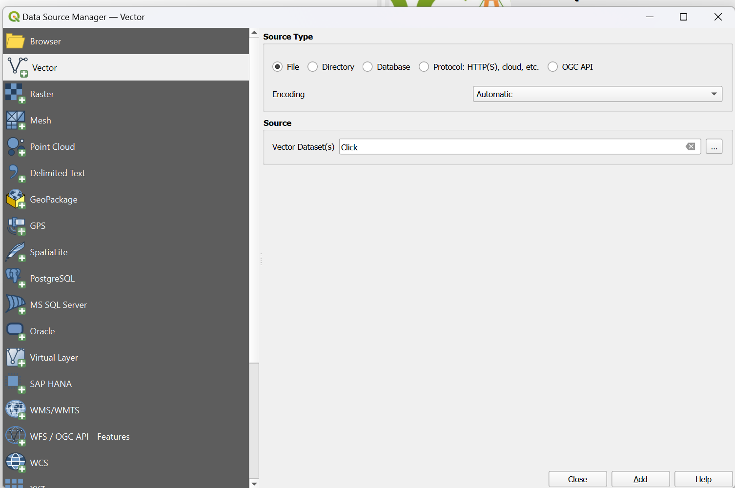
QGIS - Loading in Geospatial files in QGIS

Geospatial Formats

The two most common ways geospatial data are represented in files are Well-Known-Text (WKT) which is a textual representation of a polygon and the geojson format which shows the coordinates and type of geojson format.

Both Python and Snowflake have capabilities to work with these 3 formats and parse them so they can be used in geography functions

WKT Format

#Example 2 using WKT format

from shapely import wkt

brisbane_bbox = “POLYGON ((153.012021 -27.471741, 153.012021 -27.462598, 153.032931 -27.462598, 153.032931 -27.471741, 153.012021 -27.471741))”

brisbane_poly = wkt.loads(brisbane_bbox)

Python – Loading in GeoJSON

The libraries geojson, shapely and json need to be installed.

#EXAMPLE 1 working with a geojson format

import json

import geojson

from shapely.geometry import shape

geojson_example = {

"coordinates": [[[153.01202116, -27.47174129], [153.01202116, -27.46259798], [153.03293092, -27.46259798], [153.03293092, -27.47174129], [153.01202116, -27.47174129]]],

"type": "Polygon"

}

geojson_json = json.dumps(geojson_example)

# Convert to geojson.geometry.Polygon

geojson_poly = geojson.loads(geojson_json)

poly = shape(geojson_poly ))

Snowflake

GeoJSON and WKT format can also be loaded into snowflake and converted to a geometry using the following commands:

#converting Well-Known-Text into geography format

SELECT ST_GEOGRAPHYFROMWKT('POLYGON ((153.012021 -27.471741, 153.012021 -27.462598, 153.032931 -27.462598, 153.032931 -27.471741, 153.012021 -27.471741))');

#Converting Geojson to geography format

SELECT TO_GEOGRAPHY('{

"coordinates": [[[153.01202116, -27.47174129], [153.01202116, -27.46259798], [153.03293092, -27.46259798], [153.03293092, -27.47174129], [153.01202116, -27.47174129]]],

"type": "Polygon"

}

')

Step 4: Data Matching

Match the dataset records with the appropriate mesh blocks based on their geographical coordinates. This involves linking each data point to the corresponding mesh block within which it is located.

Tip:

Geospatial functions which are supported in big data warehouses and Python can be used to match geospatial data.

A common way to match two geographical objects is to see if the coordinates of the two objects intersect. An example of how to do this in Python and Snowflake is shown below.

In Python

Data matching can be done using the shapely library intersects function.

from shapely import wkt, intersects

shape1 = wkt.loads("POLYGON ((153.012021 -27.471741, 153.012021 -27.462598, 153.032931 -27.462598, 153.032931 -27.471741, 153.012021 -27.471741))")

shape2 = wkt.loads("POLYGON ((153.012021 -27.471741, 153.032931 -27.462598, 153.012021 -27.471741))")

shape_int = intersects(shape1, shape2)

print(shape_int)


In Snowflake

Data matching can be done using the ST_Intersects function. One of the advantages of using big data warehouses including Snowflake to geospatially match data is that it leverages its highly scalable infrastructure to quickly complete geospatial processing.

WITH geog_1 as (

SELECT ST_GEOGRAPHYFROMWKT('POLYGON ((153.012021 -27.471741, 153.012021 -27.462598, 153.032931 -27.462598, 153.032931 -27.471741, 153.012021 -27.471741))') as poly

),

geog_2 as (

SELECT ST_GEOGRAPHYFROMWKT('POLYGON ((153.012021 -27.471741, 153.022021 -27.465, 153.032931 -27.462598, 153.012021 -27.471741))') as poly

)

SELECT

g1.poly, g2.poly

FROM geog_1 as g1

INNER JOIN geog_2 as g2

on ST_INTERSECTS(g1.poly, g2.poly)

Step 5: Attribute Joining

If your dataset and mesh blocks data have common attributes (e.g., unique identifiers), perform attribute joins to combine information from both datasets. This allows you to enrich your dataset with additional details associated with mesh blocks.

Step 6: Quality Assurance

Verify the accuracy of the spatial integration by checking for any discrepancies or errors. Ensure that each data point is correctly associated with the corresponding mesh block.

Tip:

geojson.io is a handy website that can help with visualising geojson data and ensure it is correct.

If you’re using Snowflake, the ST_AsGeojson command can be used to convert geography into a geojson which allows you to quickly visualise the shapes created.

Step 7: Data Analysis and Visualisation

Leverage the integrated dataset for analysis and visualisation. Explore trends, patterns, and relationships within the data at the mesh block level. Utilise geospatial tools to create maps and visual representations of the information.

Tip:

It’s worth mentioning that Snowflake has the option to create a Streamlit app within the Snowflake UI which allows for the cleaning and processing of data using Python and SQL and the interactive visualisation of data through the Streamlit App.

Read our blog which demonstrates how to predict migration patterns and create forecasts using Snowpark and Streamlit>

Snowflake also integrates really well with local Python development environments so all the initial data processing and cleaning can be done through a Snowflake API, then geography can be converted to a GeoJson or Text formal. Thereafter, libraries like plotly, folium, pydeck can be used to do complex geospatial visualisations.

Step 8: Data Storage and Management

Establish a system for storing and managing the integrated dataset, ensuring that it remains up-to-date as new data becomes available.

Consider using databases or platforms that support geospatial data.

Tip:

Geospatial datasets are usually very large and complex datasets due to the number of attributes included in a geospatial dataset, the resolution of the data and the number of records.

Cloud-based big data platforms can be an excellent option for storing geospatial data due to the low-cost of storage. Many of these platforms including also have spatial clustering options so that geospatial data in a similar location are grouped together, meaning queries for data in certain areas run more efficiently.

Snowflake (Enterprise Edition or Higher) also has an option to add a search optimisation to geospatial data tables to optimise the performance of queries that use geospatial functions.

Step 9: Documentation

Document the integration process, including the source of mesh block boundaries, any transformations applied, and the methods used for data matching. This documentation is essential for transparency and replicability.

By following these above steps, you can effectively incorporate mesh blocks into your datasets, enabling a more detailed and location-specific analysis of the information at the mesh block level.


Geography – Boundaries & Insights – Australia

This free dataset from The Proptech Cloud is available for seamless access from Snowflake Marketplace.

The intellectual property rights for all content in this blog are exclusively held by Data Army and The Proptech Cloud. All rights are reserved, and no content may be republished or reproduced without express written permission from us. All content provided is for informational purposes only. While we strive to ensure that the information provided here is both factual and accurate, we make no representations or warranties of any kind about the completeness, accuracy, reliability, suitability, or availability with respect to the blog or the information, products, services, or related graphics contained on the blog for any purpose.

Subscribe to our newsletter

Subscribe to receive the latest blogs and data listings direct to your inbox.

Read more blogs from The Proptech Cloud

Crafting a Storm Surge and Hurricane Risk Rating for Coastal Properties

A high-level approach to developing a storm surge and hurricane risk rating system to guide stakeholders with a vested interest in coastal properties.

How Proptech Is Revolutionising Real Estate

Proptech is the dynamic intersection of property and technology, and it’s reshaping real estate. And there’s still a huge potential for growth.

What is the Australian Statistical Geography Standard (ASGS)?

The ASGS is used to better understand where people live and how communities are formed.

How to Incorporate Mesh Blocks into Datasets

Mesh blocks can enhance the precision and relevance of geospatial and proptech analyses. Here are some tips and steps to incorporate mesh blocks into datasets.

Australia’s Migration Trends: Where Are People Moving To?

This detailed visual analysis for Australia’s major capital cities breaks down how net migration trends are evolving across different regions.

Top Real Estate Technology Global Events

Top Real Estate Technology Global Events

As the real estate industry continues to evolve at a rapid pace, staying abreast of the latest trends, technologies, and innovations is crucial for professionals seeking to leverage the full potential of real estate technology and proptech.

For anyone in property and real estate, attending global proptech events offers a chance to integrate into the wider real estate technology industry. 

Top 3 reasons why these events are valuable

1. Networking, learnings and potential partnerships

A diverse mix of professionals allow for broader networking opportunities than what your local market may offer. Particularly in overseas markets where the proptech industry may be more mature or advanced compared with your local region, these events allow you to connect with leaders, potential customers, and collaborators who might offer valuable learnings, insights to trends and new technology, alternative business models or a global perspective into the market and competition. These events could offer a platform for gaining feedback and validation, or even to identify and recruit talent.

2. Brand visibility and marketing

Participation at these events may significantly increase a business’ visibility within the global industry; even more so if you attend as a speaker or exhibitor. An effective platform to showcase innovations, solutions, and success stories to a targeted audience, high visibility can enhance brand recognition, attract leads or other marketing opportunities.

3. Investor engagement

Often attended by venture capitalists, angel investors, and other financial backers actively seeking to invest in promising startups, these events can offer potential pitching sessions, one-on-one meetings, and informal networking opportunities. 

Global Real Estate Technology and Proptech events

2024 delivers a range of global events dedicated to real estate technology and proptech, offering plenty of opportunities for learning, networking, and growth. Varying from conferences to interactive expos, these events bring together thought leaders, innovators, and practitioners from around the world. Here is our round-up of top global events:

Event

Description

Location

Dates

RETCON 2024Real Estate’s Leading Technology & Innovation ConferenceNew York, USA1-3 April
PropTech SummitPropTech Summit is the new trade fair and conference for the PropTech industryHamburg, Germany10-11 April
CRETech LondonThe World’s Leading Built World Innovation and
Sustainability Conference Series
London, UK8-9 May
PropTech Symposium DenmarkExciting debates, startup showcases, and insights from international thought leadersCopenhagen, Denmark13 May
Future of Construction SummitThe annual gathering for the people and companies redefining Australia’s construction industryBrisbane, Australia14-15 May
Property Technology ConfexA Digital & Sustainable Built Environment –
Investing, Selling, Managing and Operating
Dubai, UAE3-4 June
Proptech ViennaThe networking conference on innovation, technology and sustainability in the international real estate industry, connecting tech and real estate experts with startups, scaleups, investors, business angels, VCs and industry associations.Vienna, Austria13 June
Australian Proptech SummitProptech solutions for Australia’s new commercial and residential realitySydney, Australia30 July – 1 August
Inman ConnectThrough immersive experiences, innovative formats, and an unparalleled lineup of speakers, this gathering becomes more than a conference — it becomes a collaborative force shaping the future of our industrLas Vegas, USA30 July – 1 August
iOi Summit by NARPropTech leaders and futurists, investors, and forward-thinking real estate professionals come together to fuel the future of the industry.Chicago, USA28-29 August
PropTech ConnectEurope’s largest proptech  eventLondon, UK4-5 September
REAL PropTech ConferenceGermany’s most important conference on PropTech, digitalisation and transformation of the construction and real estate industryFrankfurt am Main, Germany4-5 September
BlueprintThe premier event for industry executives, real estate & construction tech startups, and VCs.Las Vegas, USA17-19 September
Expo Real 2024Expo Real is the most important trade fair for the real estate industry and offers a comprehensive overview of developments, topics, innovations and solutions in the real estate industry.Dubai, UAE7-9 October
Proptech Forum 2024An event to unite proptech founders and teams collaborating on the future of the industry.Sydney, Australia17 October
Urban Tech ForwardUrban Tech Forward aims to accelerate the development of net-zero cities. Designed to rethink spaces where people live and work – through the prism of decarbonisation and resilience – it brings together urban tech innovators, VCs, real estate developers, policy-makers and most prominent entrepreneurs to shift the way we build and make real progress on achieving a zero-carbon future.Warsaw, Poland25-26 October
CRETech New YorkThe World’s Leading Built World Innovation and
Sustainability Conference Series
New York, USA13-14 November
Home apti AwardThe apti award recognises the most innovative Tech provider and startups in the international Real Estate sector. Both national and international PropTechs have the opportunity to apply in the categories.Palais Berg, Austria14 November

Other Considerations

Other than factoring in the cost and time associated with traveling and attending these global events, consider the relevance and quality, because not all events are created equal.

Check for alignment and relevance with your niche and strategic focus.

And lastly, with the growing range of digital alternatives, consider whether virtual events can offer you similar benefits.


Subscribe to our newsletter

Subscribe to receive the latest blogs and data listings direct to your inbox.

Read more blogs from The Proptech Cloud

Crafting a Storm Surge and Hurricane Risk Rating for Coastal Properties

A high-level approach to developing a storm surge and hurricane risk rating system to guide stakeholders with a vested interest in coastal properties.

How Proptech Is Revolutionising Real Estate

Proptech is the dynamic intersection of property and technology, and it’s reshaping real estate. And there’s still a huge potential for growth.

What is the Australian Statistical Geography Standard (ASGS)?

The ASGS is used to better understand where people live and how communities are formed.

How to Incorporate Mesh Blocks into Datasets

Mesh blocks can enhance the precision and relevance of geospatial and proptech analyses. Here are some tips and steps to incorporate mesh blocks into datasets.

Australia’s Migration Trends: Where Are People Moving To?

This detailed visual analysis for Australia’s major capital cities breaks down how net migration trends are evolving across different regions.

The Role of Data in Real Estate Decisions

The Role of Data in Real Estate Decisions

Businesses use a wide range of data to confidently analyse trends, forecast changes, and identify opportunities. In today’s competitive real estate industry, the data behind informed business decisions can be the difference between success and failure.

Why is data-driven decision-making so important in real estate?

With the advent of big data and accessibility of data, companies are now able to make more accurate and strategic decisions by analysing information, key trends and metrics. Data-driven decision-making has become critical in real estate because it allows businesses to identify opportunities, reduce risks and maximise returns on investments.

Using data in real-estate decisions

Some examples may include:

  • Real estate investment decisions

    Real estate and related data as diverse as historical sales data, demographics, market demand, property valuations can be used to identify profitable investment and development opportunities, determine a value of a property and assess potential returns on property investments.

  • Retail analytics

    Property data together with foot traffic data, demographics, sales data, can play a role in location selections and market expansion decisions. It will also influence merchandising decisions such as retail promotions and campaigns, product placement, store layout and inventory management.

  • Real estate sales decisions

    By analysing current and historical market trends, businesses can determine optimal pricing strategies for properties. Similarly demographic data can be used to identify the target audience for a particular property and inform advertising and marketing efforts.

  • Mortgage and financing decisions

    For risk assessments, lenders use property data to evaluate the value and condition of collateral for mortgage loans, determining loan eligibility and interest rates.
    On the flipside, credit scoring models may incorporate property data to evaluate borrower creditworthiness.

  • Government and urban planning

    Urban planners use property data to identify areas in need of infrastructure development, such as roads, schools, and utilities. Governments may use property data to enforce zoning regulations and property tax assessments.

  • Building and construction planning

    Property data aids in estimating construction costs, project timelines, and feasibility studies.

  • Insurance underwriting and claims

    Insurers consider property data when determining premiums and coverage for homeowners and property insurance policies. Property data may play a role in processing claims by verifying property details and assessing damage.

  • Environmental impact assessment

    Property, environmental, regulatory and geospatial data may all factor into decisions made concerning property projects.

Tips for interpreting and analysing property data

While data-driven decision-making is a valuable tool in real estate, it is important to understand how to properly analyse and interpret property data.

Here are some tips to keep in mind:

  • Data Accuracy

    Ensure the data you’re using is accurate and up-to-date. Rely on reputable sources and verify the information where possible.

  • Compare and Contrast

    Don’t make decisions based on a single data point. Compare property data from different sources and periods to identify trends and outliers.

  • Consider Context

    Understand the broader economic and market context in which the data exists. External factors like interest rates, local regulations, and economic conditions can significantly impact real estate data.

  • Data Visualisation

    Utilise data visualisation tools to transform complex data sets into easy-to-understand graphs and charts. Visual representations can highlight patterns and trends.

  • Consult Experts

    When in doubt, seek advice from experienced proptech professionals or data scientists and analysts. They can provide valuable insights and guidance in interpreting property data effectively.

  • Human Judgement

    Don’t ignore intuition and personal experience entirely. Data is important, but it should be used to inform decisions, not replace human judgement.

As we’ve explored, various types of data play a pivotal role in shaping business decisions. In an era of big data and accessible information, real estate professionals have the tools at their disposal to analyse trends, forecast changes, and seize opportunities like never before.

Businesses can navigate the intricate terrain of real estate with greater precision, with data illuminating the path.

Human judgment and expertise are still indispensable. Seek out experts, draw from your intuition, and let data guide your decisions, not dictate them.

    Read more blogs from The Proptech Cloud

    Crafting a Storm Surge and Hurricane Risk Rating for Coastal Properties

    A high-level approach to developing a storm surge and hurricane risk rating system to guide stakeholders with a vested interest in coastal properties.

    How Proptech Is Revolutionising Real Estate

    Proptech is the dynamic intersection of property and technology, and it’s reshaping real estate. And there’s still a huge potential for growth.

    What is the Australian Statistical Geography Standard (ASGS)?

    The ASGS is used to better understand where people live and how communities are formed.

    How to Incorporate Mesh Blocks into Datasets

    Mesh blocks can enhance the precision and relevance of geospatial and proptech analyses. Here are some tips and steps to incorporate mesh blocks into datasets.

    Australia’s Migration Trends: Where Are People Moving To?

    This detailed visual analysis for Australia’s major capital cities breaks down how net migration trends are evolving across different regions.

    What Is A Property?

    What Is A Property?

    The definition of a property is something that has troubled many proptechs and users of property data for some time. The concept seems relatively simple until you try to write a definition.

    Let’s consider, one definition might be:

    “A property is a piece of land or building that is owned or possessed by someone or something.”

    Great, we nailed it!

    But then someone asks “what about leaseholds?”.

    OK. Let’s modify the definition to something like,

    “A property is a piece of land or building that can be owned or leased by someone or something.”

    Seems to cover everything…

    So does a sublet, like a desk or office in a co-working space, count as a property?

    I can lease a granny flat, is that a property?

    What about trailer parks? Is that one property or multiple properties for each site?

    And the examples keep coming!

    Eventually the conversation changes to just simply define everything as a property.

    Why Can’t I Define Everything as a Property?

    Defining everything as a “property” is definitely an option, but it has its own drawbacks.

    Firstly, obtaining a deep understanding of a property when everything is a property would be difficult.

    Integrations to other data sets is extremely difficult taking this approach, as the definition is quite fluid and can lead to inconsistent results.

    For example, one data set may contain data on a granny flat and another on a main dwelling on the same parcel of land.

    An address match would be used to link the two data sets, and attributes from the granny flat added to the main dwelling, which isn’t correct.

    Another issue with defining everything as a property is alternate addresses, which could be mistaken for secondary dwellings, resulting in an over-classification of properties.

    So, What is a Property?

    Well, it depends. Consider,

    • If you are bank processing mortgage applications, what would a property mean in that context?
    • If you are a website listing private vacation stays, what would a property mean in that context?
    • If you are a website listing hotel accommodation, what would a property mean in that context?
    • If you are a website listing flat shares, what would a property mean, then?
    • If you are a government collecting statistics on the population, what would a property mean in that context?
    • If your customers were property developers, do they care about sub-lets or strata units?

    There is no one definition of a property.

    A property can be whatever it means to your business and your customers. But it is important to form a view, and be consistent in executing that approach. Inconsistency in approaches to handling the data can lead to data issues that can impact your business.

    Tips when Deciding on a Definition of a Property

    • Generally, the broader the definition of a property used, the less depth of information is available.
    • Try to ensure you have integration attributes available for your definition so third party data sets can be integrated.
    • In most use cases, a property definition would align to one of the key concepts in property data: parcels, titles, addresses, or buildings. Read our post on the differences between parcels, titles, addresses and addresses.
    • Finally, extra caution needs to be taken when integrating with third-party property data sets to ensure definitions align, or the differences known and catered for. Research third party data sets using a source like theproptechcloud.com to ensure you achieve your desired outcome.

    Read more blogs from The Proptech Cloud

    Crafting a Storm Surge and Hurricane Risk Rating for Coastal Properties

    A high-level approach to developing a storm surge and hurricane risk rating system to guide stakeholders with a vested interest in coastal properties.

    How Proptech Is Revolutionising Real Estate

    Proptech is the dynamic intersection of property and technology, and it’s reshaping real estate. And there’s still a huge potential for growth.

    What is the Australian Statistical Geography Standard (ASGS)?

    The ASGS is used to better understand where people live and how communities are formed.

    How to Incorporate Mesh Blocks into Datasets

    Mesh blocks can enhance the precision and relevance of geospatial and proptech analyses. Here are some tips and steps to incorporate mesh blocks into datasets.

    Australia’s Migration Trends: Where Are People Moving To?

    This detailed visual analysis for Australia’s major capital cities breaks down how net migration trends are evolving across different regions.

    Properties, Parcels, Titles and Addresses. What’s The Difference?

    Properties, Parcels, Titles and Addresses. What’s The Difference?

    ​Properties, parcels, titles, addresses. These terms can sometimes be used interchangeably, but are they the same thing?

    And if not, what’s the difference? Let’s discuss it here.

    Parcel

    A “Parcel” refers to a specific portion or subdivision of land within a larger property.

    It is a defined area of land with distinct boundaries and can have its own unique identification number. Parcels are often used for administrative or legal purposes, such as land registration.

    A parcel can sometimes be referred to a Lot and Plan, which describes the identification number components in some states (e.g. NSW).

    A property can have more than one parcel associated with it, e.g. a farm may be made up of several parcels but when it is sold, a parcels are included in the transfer.

    Volume Folio

    The “Volume Folio” or “Title Reference” is a unique identifier assigned to a property title in the Australian land registration system. It represents the registered ownership and legal description of a property.

    The Volume refers to the specific book or register where the title is recorded, while the Folio refers to the page or entry within that volume. The Title Reference is commonly used in land transactions and legal documentation to accurately identify a property.

    Address

    An “Address” refers to the specific location or postal address of a property. It includes elements such as the street number, street name, suburb, state, and postcode.

    The address is used for communication, mail delivery, and identification of a property’s location.

    In Australia, addresses are often structured in a standardised format to ensure consistency and facilitate efficient mail handling. A property can have more than one address associated with it, e.g. corner blocks and back lanes.

    Property

    A “Property” can be many things depending on the context of the data. Some State Governments will provide an identifier for a property, which relates generally to land which can be bought and sold.

    In this context, a Property can have one or more Parcels and usually one or more addresses and be recorded on a Volume Folio.

    Read our blog What is a Property to gain a greater understanding of why it is difficult to define a “Property”.

    Can a parcel appear on more than one volume folio?

    No, a parcel typically cannot appear on more than one Volume Folio in the Australian land registration system. A parcel of land is usually associated with a specific Volume Folio, which represents the registered ownership and legal description of that particular property.

    Are addresses unique?

    In theory, yes, addresses are unique.

    However, in reality, no.

    Addresses are generally unique, but there are always exceptions. The origin of the address data will influence whether addresses are unique.

    A few examples where address uniqueness can pose an issue:

    • Unit addresses, where identifying information like unit numbers have been left off.
    • Rural addresses, where a property does not have a frontage to a public road.
    • Multi-building complexes, where the same unit number appears in multiple buildings and the building names are omitted.

    To delve further into this topic, reference our handy article on Useful Websites for Australian Properties, Parcels and Addresses for links to websites to research parcels, volumes and folios, addresses and properties.

    Read more blogs from The Proptech Cloud

    Crafting a Storm Surge and Hurricane Risk Rating for Coastal Properties

    A high-level approach to developing a storm surge and hurricane risk rating system to guide stakeholders with a vested interest in coastal properties.

    How Proptech Is Revolutionising Real Estate

    Proptech is the dynamic intersection of property and technology, and it’s reshaping real estate. And there’s still a huge potential for growth.

    What is the Australian Statistical Geography Standard (ASGS)?

    The ASGS is used to better understand where people live and how communities are formed.

    How to Incorporate Mesh Blocks into Datasets

    Mesh blocks can enhance the precision and relevance of geospatial and proptech analyses. Here are some tips and steps to incorporate mesh blocks into datasets.

    Australia’s Migration Trends: Where Are People Moving To?

    This detailed visual analysis for Australia’s major capital cities breaks down how net migration trends are evolving across different regions.