What’s The Difference Between Proptech and Contech?

What’s The Difference Between Proptech and Contech?

In real estate and construction, proptech and contech have emerged in more recent years with the potential to disrupt and digitise.

These technologies are driving innovation across industries, yet they each serve distinct roles.

We uncover the nuances and distinctions between proptech and contech here.

Defining Proptech and Contech

Proptech

Proptech is the broad umbrella term encompassing all digital innovations that enhance and streamline processes within the real estate industry.

It covers everything from property management and transactions to marketing and customer engagement.

While its reach can extend to the construction phase of property development, proptech’s focus is on optimising the entire lifecycle of real estate—from conception to management.

Here are examples of startups and more established proptech companies making waves in real estate:

  • Archistar specialises in AI-driven architectural design and property analytics, helping developers and architects assess building potential.
  • Propic uses AI and machine learning to enhance real estate processes such as sales, property management and customer service automation.
  • Little Hinges specialises in digital property marketing solutions with virtual property tours, floorplans, virtual staging, global platform and an Insights portal.
  • Equiem provides tenant engagement technology for commercial real estate, focusing on improving communication and services between landlords and tenants.
  • CoreLogic, a provider of financial, property, consumer information services known for their comprehensive real estate data services, is also a leading player in AI-powered housing data and analytics.
  • AirBNB is well known as a short-term rental platform, however, Airbnb’s disruption and influence on the traditional property management and rental markets has defined its role in the proptech sector.
  • Zillow is a comprehensive platform connecting renters, buyers and sellers to facilitate seamless transitions into their dream homes.

Contech

While proptech may briefly address construction, contech is solely focused on the construction process, providing solutions that improves safety, efficiency and/or precision on the job site. In general, it refers to the technologies that directly impact the planning, design and building of structures.

Here are some notable contech companies making an impact on the construction industry:

  • Autodesk is known for their Design and Make Platform for planning, design, construction and project operation.
  • Procore’s cloud-based construction management platform streamlines every process from pre-construction to closeout.
  • Built Robotics has a mission to build the robots that build the world.
  • Rhumbix is a software company which consolidates and digitises field reporting workflows into one app.
  • Matterport is a spatial data company focused on digitising and indexing the built world with their all-in-one 3D data platform.
  • cmBuilder offers 4D construction site logistics with fast & easy cloud-based workflows, powerful sequencing simulation capabilities, and unparalleled real-time collaboration.

Key Differences Between Proptech and Contech

Scope of Application:

  • Proptech covers a broad spectrum of digital tools and platforms used across the real estate industry, including everything from smart property management systems to online marketplaces that simplify buying, selling, and renting properties.
  • Contech is focused on the construction phase of property development. It involves tools and technologies that assist architects, engineers and builders in creating physical structures, from advanced construction materials to innovative design software.

Target Audience:

  • Proptech primarily targets real estate professionals, including developers, property managers, realtors, investors, and tenants. Its tools are designed to enhance customer experiences, streamline transactions and provide valuable market insights.
  • Contech caters specifically to construction professionals—architects, contractors, engineers, and construction workers— with a focus on improving the efficiency, safety and/or quality of the construction process.

Technological Impact:

  • Proptech typically integrates technologies such as Big Data, Artificial Intelligence, Virtual and Augmented Reality, IoT and Blockchain. These innovations have the power to transform traditional real estate practices, offering smarter, more efficient ways to manage properties, conduct transactions and interact with clients.
  • Contech typically leverages technologies like Building Information Modeling (BIM), prefabrication, robotics, drones or wearable tech. These tools are generally designed to enhance and optimise the construction process, reduce risks and improve productivity on-site.

Proptech and Contech: Better Together

While proptech and contech operate in different domains, their intersection is where the magic happens.

Proptech’s digital solutions often complement contech’s innovations, creating a seamless flow from project planning and construction to property management and sales.

For instance, a real estate developer might use contech to design and build a property, then rely on proptech platforms to market, lease or sell the units.

Proptech and contech both offer powerful tools that drive efficiency, safety and profitability in real estate and construction.

By leveraging these technologies, professionals can navigate industry complexities with greater agility and success.

At The Proptech Cloud, we believe in the game-changing power of both proptech and contech.

Together, they’re reshaping the future of real estate—one innovative solution at a time.


Subscribe to our newsletter

Subscribe to receive the latest blogs and data listings direct to your inbox.

Read more from The Proptech Cloud

Useful Websites for Australian Properties, Parcels and Addresses

Researching the existence of a property or verifying data can be challenging, often resulting in conflicting answers. Depending on your definition of a property, it may be necessary to visit various websites to validate property data.

Understanding Housing Affordability: Key Metrics and Statistics

Housing affordability is a significant concern in many parts of the world, affecting the quality of life and economic wellbeing of individuals and families.

To understand the dynamics of housing affordability we need to take a detailed look at a range of different metrics and statistics to gain a full picture.

The Three Primary Methods of Real Estate Data Integration

cLearn the three primary methods of real estate data integration—geospatial relationships, title matches, and address matching—to improve accuracy, insights, and decision-making.

What’s the Difference Between GDA94 and GDA2020?

Geodetic datums, or geodetic systems, are often used by proptechs. Here is a rundown of everything you need to know about the different geodetic datums we use and reference in Australia.

Alternative Data: What Is It, Who Uses It And Why It Matters

Discover the powerful intel alternative data can offer. Learn why businesses and investors are turning to non-traditional data sources for deeper insights and smarter decisions.

The Property Lifecycle

The Property Lifecycle

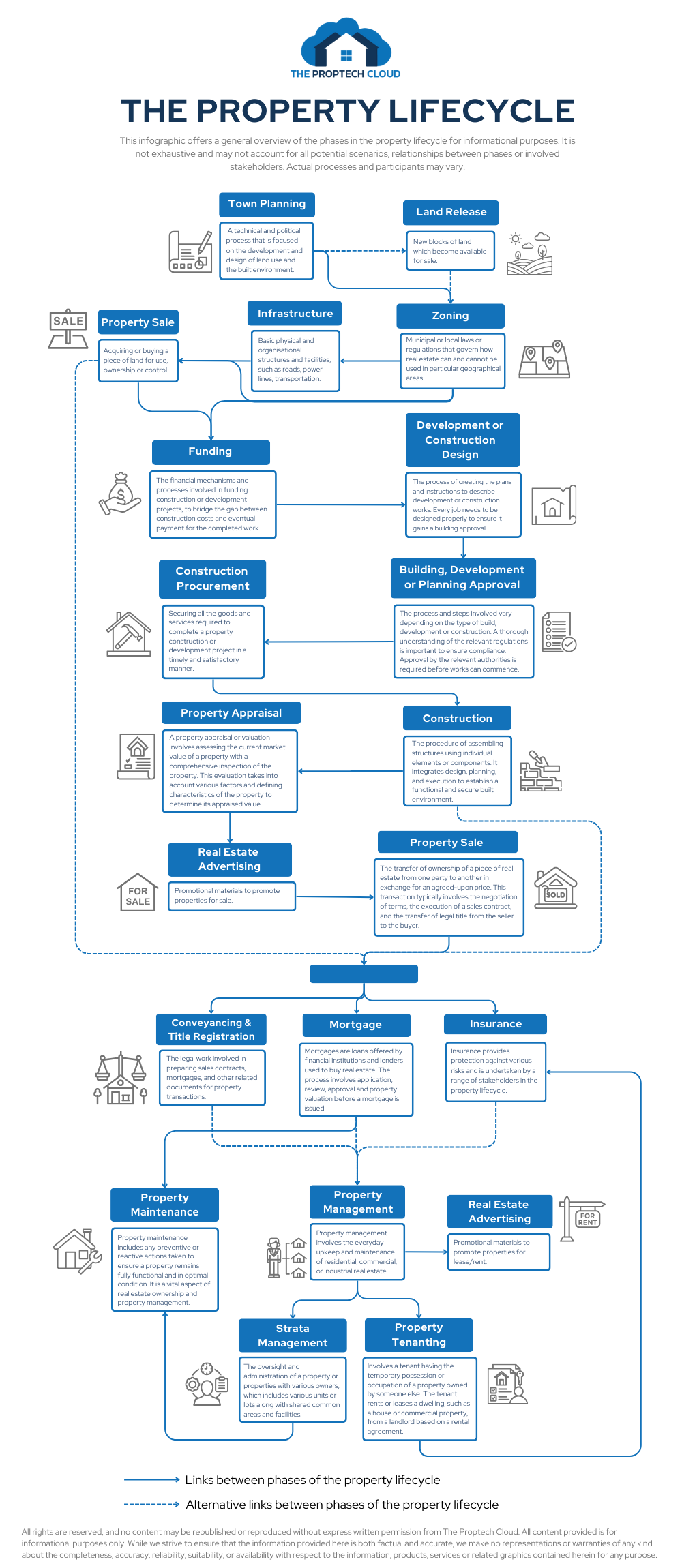
Discover the property lifecycle and how it brings together various sectors such as government, legal, construction, finance, and insurance, while connecting a wide range of professionals.

This infographic offers a high-level overview of the key phases and processes.

The Property Lifecycle Infographic

Read more from The Proptech Cloud

Useful Websites for Australian Properties, Parcels and Addresses

Researching the existence of a property or verifying data can be challenging, often resulting in conflicting answers. Depending on your definition of a property, it may be necessary to visit various websites to validate property data.

Understanding Housing Affordability: Key Metrics and Statistics

Housing affordability is a significant concern in many parts of the world, affecting the quality of life and economic wellbeing of individuals and families.

To understand the dynamics of housing affordability we need to take a detailed look at a range of different metrics and statistics to gain a full picture.

The Three Primary Methods of Real Estate Data Integration

cLearn the three primary methods of real estate data integration—geospatial relationships, title matches, and address matching—to improve accuracy, insights, and decision-making.

What’s the Difference Between GDA94 and GDA2020?

Geodetic datums, or geodetic systems, are often used by proptechs. Here is a rundown of everything you need to know about the different geodetic datums we use and reference in Australia.

Alternative Data: What Is It, Who Uses It And Why It Matters

Discover the powerful intel alternative data can offer. Learn why businesses and investors are turning to non-traditional data sources for deeper insights and smarter decisions.

Crafting a Storm Surge and Hurricane Risk Rating for Coastal Properties

Crafting a Storm Surge and Hurricane Risk Rating for Coastal Properties

In an era where climate change is intensifying the frequency and severity of storms and hurricanes, especially in coastal regions, understanding and quantifying the associated risks is critical.

According to the National Geographic Society, a storm surge is a rise in sea level that occurs during tropical cyclones, which are intense storms also known as typhoons or hurricanes.

The storms produce strong winds that push the water into shore which can lead to flooding and pose a real threat in coastal regions.

To help understand these risks, a Storm Surge and Hurricane Risk Rating score can provide property owners, developers, real estate agents, insurers, urban planners, local governments, buyers and investors with a clear picture of a property’s vulnerability to these natural disasters.

These stakeholders will be conducting their own necessary research, and a risk rating system can offer an indicative metric to guide their decisions.

Why is a Storm Surge and Hurricane Risk Rating Important?

Understanding storm surge and hurricane risks is crucial for building a resilient society.

Natural catastrophes pose significant challenges, and quantifying these risks can aid in better preparation and prompt responses.

Strengthening homes and incentivising homeowners to invest in property fortification can reduce potential losses. Accurate risk assessments and reliable data can allow insurers to offer discounts for mitigation actions, enhance home resale values, and reveal the increased costs to mortgage issuers due to natural disasters.

Achieving resilience relies on expert understanding of the real estate ecosystem and the benefits of informed mitigation strategies.

Steps to build a Storm Surge and Hurricane Risk Rating

1. Defining scoring criteria and scale

The foundation of a risk rating system is a clear and understandable scale, such as 1 to 10, with each number representing a different level of risk.

Establishing specific criteria for assessment is also essential for a well-rounded evaluation.

2. Key factors to consider

Several factors contribute significantly to a property’s risk from storm surges and hurricanes:

Proximity to coast


  • Proximity to Coastline: The closer a property is to the coastline, the higher the risk of storm surge impacts.
  • Elevation and Topography: Properties at higher elevations or with certain topographical features may have reduced risk.
  • Historical Data: Analysing past hurricane and storm surge incidents from historical weather databases and local government records can provide critical insights into potential future risks.
  • Local Climate Trends: Understanding the local weather patterns can help predict the likelihood of storms.
Natural barriers
  • Flood Zone Designation: Properties in designated flood zones face a heightened risk. Flood risk information is generally available from Local Councils.
  • Building Design and Materials: Construction that is designed to be resilient against high winds and flooding can mitigate risk.
  • Infrastructure and Preparedness: Robust local infrastructure and emergency plans can play a vital role in risk reduction.
  • Natural Barriers: The presence of natural features, such as dunes or wetlands that can absorb storm impacts, reduces risk.
  • Regional Planning: Effective community and regional planning and zoning can mitigate potential damage. Consult local zoning laws and development plans for more property-specific.

3. Assigning weights to each factor

Assigning appropriate weights to each of the above factors based on its impact on overall risk ensures that the score accurately reflects the property’s vulnerability.

Use expert consultations and statistical analysis to determine appropriate weights, and adjust weights based on real-world data and expert feedback.

4. Data collection and analysis

Gathering and analysing data, including GIS mapping, climate records and historical event data, is crucial to assigning accurate sub-scores for each criterion. Cross-referencing multiple sources will ensure data accuracy and statistical software can be used for thorough analysis.

5. Calculating the overall score

By aggregating these sub-scores, considering their respective weights, we arrive at a comprehensive risk rating for each property. Using a formula or algorithm will ensure consistency in calculations. Further validating the scoring system with sample properties will help improve accuracy.

6. Validation and adjustment

It’s vital to validate and adjust the rating system against historical data and expert analysis to ensure its reliability and accuracy. Regularly review and update the criteria and weights based on new data.

Checklist

7. Providing risk mitigation recommendations

Along with the risk score, offering advice on how to reduce a property’s vulnerability to storm surges and hurricanes can be highly beneficial. Suggestions such as upgrading building materials, improving drainage systems or investing in flood barriers can form a checklist of actionable steps to reduce a property’s vulnerability.

8. Regular updates and re-evaluations

Continuously updating the risk rating system to reflect environmental changes, infrastructure developments and updated data is crucial. This includes regular reviews, incorporating new data and tech advancements can improve the risk rating system. 

Building Resilience with Accurate Risk Ratings

Stakeholders can create a robust and reliable risk rating system that enhances safety and preparedness in coastal areas.

A well-developed Storm Surge and Hurricane Risk Rating can provide essential information for making educated decisions about property development, insurance and risk management.

As the world grapples with the increasing challenges of climate change, these tools become ever more critical in our collective efforts to build resilient communities.

Subscribe to our newsletter

Subscribe to receive the latest blogs and data listings direct to your inbox.

Read more from The Proptech Cloud

Useful Websites for Australian Properties, Parcels and Addresses

Researching the existence of a property or verifying data can be challenging, often resulting in conflicting answers. Depending on your definition of a property, it may be necessary to visit various websites to validate property data.

Understanding Housing Affordability: Key Metrics and Statistics

Housing affordability is a significant concern in many parts of the world, affecting the quality of life and economic wellbeing of individuals and families.

To understand the dynamics of housing affordability we need to take a detailed look at a range of different metrics and statistics to gain a full picture.

The Three Primary Methods of Real Estate Data Integration

cLearn the three primary methods of real estate data integration—geospatial relationships, title matches, and address matching—to improve accuracy, insights, and decision-making.

What’s the Difference Between GDA94 and GDA2020?

Geodetic datums, or geodetic systems, are often used by proptechs. Here is a rundown of everything you need to know about the different geodetic datums we use and reference in Australia.

Alternative Data: What Is It, Who Uses It And Why It Matters

Discover the powerful intel alternative data can offer. Learn why businesses and investors are turning to non-traditional data sources for deeper insights and smarter decisions.

Could a Revamp of Australian Property Planning Rules Solve Some of Australia’s Housing Issues?

Could a Revamp of Australian Property Planning Rules Solve Some of Australia’s Housing Issues?

Rising property prices and high costs of living means the Australian dream of home ownership is slipping further and further away for many. Could an overhaul of Australian property planning rules offer a solution?

In recent discussions during a heated ABC Q+A debate on Homeownership, Homelessness & Housing supply, the Australian dream of homeownership has taken centre stage again, unveiling a crisis that grips not just potential homeowners but extends its grasp towards the homeless and vulnerable communities across the nation.

Even those “fortunate” enough to have purchased property are feeling significant interest rate stress as cost-of-living soars in recent times. Renters are experiencing rent hikes and dealing with historically low vacancy rates.

Australia’s housing issues in the spotlight

“Fundamentally, the problem is that we’re not building enough homes,” Mr Leigh, the Assistant Minister for Competition, Charities and Treasury, told Q+A.

It’s clear that Australia requires millions more homes to meet current demand but also accommodate future population growth.

However, as it stands, governments are finding it challenging to meet their own targets.

The debate, and followed up by The Sydney Morning Herald article Do planning rules really affect house prices? The answer is clear, has cast a spotlight on a host of interconnected factors contributing to this issue.

At the heart of the matter are planning and zoning rules, which, contrary to some beliefs, significantly influence housing prices and supply. This is a contentious point, highlighted by the disagreement between Max Chandler-Mather, Greens Spokesperson on Housing & Homelessness, and Dan McKenna, CEO of Nightingale Housing, pointing to a deeper complexity within the debate.

While Shadow Assistant Minister for Home Ownership, Senator Andrew Bragg’s remarks on construction industry, skills shortage and migration underscores the multifaceted approach needed to address the crisis.

This crisis reflects broader societal issues—including a shortage in construction and trades to debates on policy, immigration, and infrastructure development.

The challenges extend to financial mechanisms of owning a home, with strategies like tapping into superannuation funds or adopting shared equity schemes considered as possible solutions (which have their own implications).

As housing prices in some states soar to record levels and impact housing affordability, the dream slips further away for many, with rising homelessness a sign of a deepening emergency.

The conversation also touched on regulatory measures like controlling rent increases and revisiting the impacts of capital gains tax and tax concessions, such as negative gearing, which has been identified as contributing factors in the price hikes over the last few decades.

A possible solution to the housing crisis

Looking beyond our shores for solutions, it’s clear that this is not an issue unique to Australia.

International examples offer alternative paths forward and suggest a re-evaluation of property planning rules.

But first, we need to understand our current property planning rules.

Captured and represented by Archistar, Australian Property Planning Rules for Land Use could provide crucial insights into land use and, potentially, relief to the crisis. The data, available via the Snowflake Marketplace, details current land use zoning applied across the nation with geospatial representation. The use of that data can help us to understand where we currently stand and offer possible solutions when variables are tweaked, such as housing density.

Another challenge in solving the housing affordability problem in Australia, and globally for that matter, is the accessibility of data. 

Archistar is helping to break down these barriers by collating national datasets for planning rules that can be easily accessed and analysed using Snowflake’s Data Platform.

The way forward

As we negotiate this national emergency, it becomes increasingly evident that a multifaceted and inclusive approach is essential.

Engaging in open discussions, exploring innovative housing policies, and reconsidering the frameworks which our housing market operates could pave the way towards a more equitable future.

The dream of homeownership, safeguarding against homelessness, and the creation of sustainable communities demand it.

Australian Property Planning Rules for Land Use

Access Archistar’s Australian Property Planning Rules and understand zoning designations and regulations across the nation.

Subscribe to our newsletter

Subscribe to receive the latest blogs and data listings direct to your inbox.
Read more from The Proptech Cloud

Useful Websites for Australian Properties, Parcels and Addresses

Researching the existence of a property or verifying data can be challenging, often resulting in conflicting answers. Depending on your definition of a property, it may be necessary to visit various websites to validate property data.

Understanding Housing Affordability: Key Metrics and Statistics

Housing affordability is a significant concern in many parts of the world, affecting the quality of life and economic wellbeing of individuals and families.

To understand the dynamics of housing affordability we need to take a detailed look at a range of different metrics and statistics to gain a full picture.

The Three Primary Methods of Real Estate Data Integration

cLearn the three primary methods of real estate data integration—geospatial relationships, title matches, and address matching—to improve accuracy, insights, and decision-making.

What’s the Difference Between GDA94 and GDA2020?

Geodetic datums, or geodetic systems, are often used by proptechs. Here is a rundown of everything you need to know about the different geodetic datums we use and reference in Australia.

Alternative Data: What Is It, Who Uses It And Why It Matters

Discover the powerful intel alternative data can offer. Learn why businesses and investors are turning to non-traditional data sources for deeper insights and smarter decisions.

What Are Mesh Blocks & How Are They Used in Real Estate

What Are Mesh Blocks & How Are They Used in Real Estate

In this article, we explore what Mesh Blocks are, how they are structured and their use in real estate and proptech.

What are Mesh Blocks?

As defined by Australian Bureau of Statistics (ABS), mesh blocks are the smallest geographical area of the Australian Statistical Geography Standard (ASGS) and ABS’s classification of Australia into a hierarchy of statistical areas.

Mesh Blocks are essentially a set of geographic boundaries designed to segment Australia into very small areas. These boundaries are used to apply a systematic grid over the entire country, dividing it into tiny sections called Mesh Blocks.

Each Mesh Block is a polygon that outlines a specific piece of land, which can range from a single block in a city to a vast, sparsely populated area in the countryside.

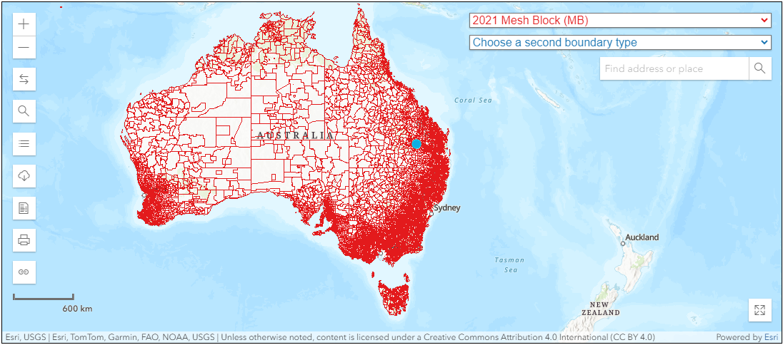
In 2021, the ABS reported 368,286 Mesh Blocks covering the whole of Australia without gaps or overlaps.

Mesh Blocks covering the whole of Australia. Source: ABS Maps


Mesh Block design

Mesh Blocks for the current ASGS Edition 3 are designed according to a standard set of design criteria first developed for ASGS 2011.

Most Mesh Blocks are designed to contain 30 to 60 dwellings, although some low dwelling count Mesh Blocks exist. They are permitted in order to account for other design criteria.

The reasons for the minimum dwelling count of Mesh Blocks is so they’re small enough to aggregate to a wide range of areas, allow comparisons between geographic regions but also prevent accidentally exposing confidential information of individuals or businesses.


Mesh Block changes

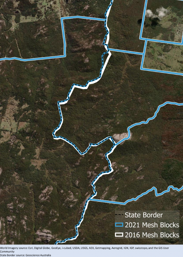
Mesh Blocks are updated (or redesigned) every 5 years to stay relevant.

Mesh Blocks for the current ASGS Edition 3 was redesigned to ensure it still meets the design criteria first developed for ASGS 2011 and reflects the growth and change in Australia’s population, economy and infrastructure.

Mesh Block Changes

Example of Mesh Block change along the border of Queensland and New South Wales. Source: Australian Bureau of Statistics

How are Mesh Blocks created?

Each Mesh Block is assigned a unique numerical code or identifier. This code is used to reference the Mesh Block in statistical databases and geographic information systems (GIS).

The format of the code can vary but often includes digits that signify hierarchical levels of geography.

In Australia, Mesh Block identifiers are 11-digit codes.

The 11-digit Mesh Block code comprises: State and Territory identifier (1 digit), and a Mesh Block identifier (10 digits).

How are Mesh Blocks used?

The ABS does not and cannot provide detailed segmentation data (Census data) that can be directly connected to individuals or businesses. Instead, they provide anonymised and aggregated data against geographic areas. Mesh Blocks are the smallest geographic area that the ABS provide statistics against, so it offers population and dwelling counts at a hyper-local level – this is particularly useful for Census analysis.

These geographic boundaries allow for the aggregation of data from individual Mesh Blocks into larger geographic units, such as suburbs, towns, cities, and regions. This hierarchical structuring makes it possible to analyse data at various levels, from very detailed local information to broader regional or national trends.

Most businesses, including proptechs, looking to augment their analysis with population segmentation data will adopt Mesh Blocks as their default level geographic unit to gain the highest level of accuracy. The popularity of Mesh Blocks mean many businesses will use it for geographic statistics regardless of whether or not the Census data is being used.

What role do Mesh Blocks play in proptech?

Mesh Blocks play a vital role in Proptech, geospatial data, and the real estate industry in Australia. Some example uses include:

Granular geographical data

Since Mesh Blocks are the smallest geographical units, providing a granular level of detail in geographic data, its precision is valuable for analysing real estate trends at a hyper-local level.

Accurate small area statistics

Mesh Blocks are designed to fulfill the need for accurate small area statistics. In Proptech, having precise data at this level is instrumental for understanding localised property markets, demographics, and trends.

Spatial mapping and analysis

Geospatial data, including Mesh Blocks, facilitates spatial mapping and analysis. Proptech platforms can leverage this data to visualise and analyse property-related information, helping users make more informed decisions based on geographical insights.

Enhanced property valuation

Proptech applications can utilise Mesh Blocks to refine property valuation models. The data on dwellings and residents at this level allows for a more nuanced understanding of property values, considering localised factors.

Land use identification

Mesh blocks broadly identify land use, such as residential, commercial, industrial, parkland, and so forth. Land use information is valuable for proptechs involved in property development, urban planning, and investment strategies.

Targeted marketing and outreach

Proptech businesses can use Mesh Block data to tailor marketing and outreach strategies to specific geographical areas. Understanding the demographics and dwelling counts at this level allows for targeted and effective location-based campaigns.

Census-driven insights

The inclusion of Census data within Mesh Blocks, such as the count of usual residents and dwelling types, provides proptech platforms with up-to-date demographic information. This can aid market analysis, customer profiling, and investment strategies.

Integration with digital boundary files

The availability of Mesh Block boundaries in digital boundary files enhances their usability in Proptech applications. These files can be readily integrated into geospatial systems, making it easier for developers and analysts to work with this geographical data.

The foundational building blocks in real estate

Mesh Blocks are foundational building blocks for geospatial and proptech applications, providing granularity and accuracy for understanding local real estate markets, demographics and land use.

To aid proptechs, The Proptech Cloud offers its Geography – Boundaries & Insights dataset which includes all mesh blocks and their spatial areas for analysis and location-based visualisation of statistics.

The integration of this important information can enhance the precision and relevance of analyses within the proptech and real estate sectors. Read our following blog to learn how to incorporate Mesh Blocks into datasets.

How to Incorporate Mesh Blocks into Datasets

Incorporating mesh blocks into datasets involves several steps to ensure seamless integration and effective utilisation of geographical information. Here’s a guide on how to incorporate mesh blocks into datasets.

Subscribe to our newsletter

Subscribe to receive the latest blogs and data listings direct to your inbox.

Read more from The Proptech Cloud

Useful Websites for Australian Properties, Parcels and Addresses

Researching the existence of a property or verifying data can be challenging, often resulting in conflicting answers. Depending on your definition of a property, it may be necessary to visit various websites to validate property data.

Understanding Housing Affordability: Key Metrics and Statistics

Housing affordability is a significant concern in many parts of the world, affecting the quality of life and economic wellbeing of individuals and families.

To understand the dynamics of housing affordability we need to take a detailed look at a range of different metrics and statistics to gain a full picture.

The Three Primary Methods of Real Estate Data Integration

cLearn the three primary methods of real estate data integration—geospatial relationships, title matches, and address matching—to improve accuracy, insights, and decision-making.

What’s the Difference Between GDA94 and GDA2020?

Geodetic datums, or geodetic systems, are often used by proptechs. Here is a rundown of everything you need to know about the different geodetic datums we use and reference in Australia.

Alternative Data: What Is It, Who Uses It And Why It Matters

Discover the powerful intel alternative data can offer. Learn why businesses and investors are turning to non-traditional data sources for deeper insights and smarter decisions.