Coordinate Reference Systems (CRS) and Geodetic Datums: What’s the difference?

Coordinate Reference Systems (CRS) and Geodetic Datums: What’s the difference?

Coordinate Reference Systems (CRS) and geodetic datums are both used to represent the Earth’s surface, but they are different concepts, and importantly, serve different purposes. We provide definitions, highlight their differences and considerations for practical applications.

Coordinate Reference System (CRS)

A CRS is a coordinate-based system that provides a standardised framework for describing and locating points on the Earth’s surface. CRS is primarily used to represent specific locations on the Earth’s surface with precision and consistency.

A CRS can also be referred to as a spatial reference system (SRS) in many cases.

It defines a set of coordinates that can be used to represent the location of a point on the Earth’s surface.

A CRS typically includes a reference point (an origin), a set of axes (coordinate axes), and a unit of measurement (such as metres).

Geodetic Datum

A geodetic datum, on the other hand, is a mathematical model that defines the shape and size of the Earth’s surface, as well as the location of a reference point (the geodetic origin) and the orientation of the axes.

A geodetic datum provides the framework for measuring and comparing positions on the Earth’s surface.

It includes parameters describing the Earth’s ellipsoidal shape (semi-major and semi-minor axes), the flattening of the Earth, and the position of the datum origin.

Geodetic datums are essential for achieving high accuracy in geospatial measurements, especially over large areas.

What’s the difference?

While a CRS and a geodetic datum both provide frameworks for representing the Earth’s surface, they are different in their scope and purpose.

They serve distinct purposes in spatial representation and measurement.

The main differences between Coordinate Reference Systems and Geodetic Datums

Coordinate Reference Systems (CRS)Geodetic Datums
USESA CRS is used to represent the location of a point on the Earth's surfaceA geodetic datum is used to define the shape and size of the Earth's surface and the reference point used to measure positions
PRIMARY FOCUSA CRS deals primarily with coordinate systemA geodetic datum deals with the underlying shape and size of the Earth's reference ellipsoid
DEFINITIONSCRS definitions typically remain consistentGeodetic datums may evolve over time due to improvements in measurement techniques and advancements in geodesy
OPTIONSMultiple CRS are availableMultiple geodetic datums are available

It’s important to note that in many cases, CRSs are defined based on specific geodetic datums, ensuring compatibility and accuracy in spatial representations.

For example, the UTM system uses the WGS84 geodetic datum.

The decision between which CRS or geodetic datum to use

There are multiple choices of both CRS and geodetic datums available for users to select from.

The choice of CRS and geodetic datum depends on various factors such as the geographic region, application, and desired level of accuracy.

Geographic Region

Geographic Region

Different regions of the world may use specific CRS and geodetic datum combinations that are optimised for that region’s geographical characteristics.

Learn about the geodetic datums we use and reference in Australia.

Applications

Application

The type of application you’re working on can influence your choice of CRS and geodetic datum.

For example, surveying and mapping applications often require high accuracy, so a CRS and geodetic datum that offer precision are chosen. On the other hand, less accurate CRS and datum choices may be suitable for applications like general-purpose Geographic Information Systems or web mapping.

Accuracy

Desired Level of Accuracy

The level of precision required for a particular project or task is a crucial deciding factor. Some CRS and geodetic datum combinations are designed to provide centimetre-level accuracy, while others may provide accuracy at the metre or even decimetre level. So the choice really depends on the project’s specific accuracy requirements.

In practice, these above factors need to be carefully considered to ensure users choose the CRS and geodetic datum that is appropriate and aligns to their needs.

Considerations include whether it accurately represents geospatial data, can be integrated seamlessly with other data sources or used in specific analysis or modeling purposes. This will help avoid errors and inconsistencies in geospatial data handling and analysis.

Practical uses for CRS and geodetic datums

In practical terms, when working with geospatial data and mapping, you often need to specify both the CRS and the geodetic datum to ensure accurate and consistent spatial referencing and calculations. Keep in mind different geographic regions and applications may use specific datums and CRS to meet their needs, so understanding the distinction between them is essential for accurate geospatial referencing and analysis.

How to set these in Snowflake

If using a Geography data type the CRS used is WGS 84 and cannot be changed.

If using the Geometry data type, the CRS (or SRS) can be set with the ST_SETSRID function. To change the CRS of a geometry, use the ST_TRANSFORM function.

SELECT
ST_TRANSFORM(
ST_GEOMFROMWKT('POINT(389866.35 5819003.03)', 32633),
3857
) AS transformed_geom;

Read more from The Proptech Cloud

Useful Websites for Australian Properties, Parcels and Addresses

Researching the existence of a property or verifying data can be challenging, often resulting in conflicting answers. Depending on your definition of a property, it may be necessary to visit various websites to validate property data.

Understanding Housing Affordability: Key Metrics and Statistics

Housing affordability is a significant concern in many parts of the world, affecting the quality of life and economic wellbeing of individuals and families.

To understand the dynamics of housing affordability we need to take a detailed look at a range of different metrics and statistics to gain a full picture.

The Three Primary Methods of Real Estate Data Integration

cLearn the three primary methods of real estate data integration—geospatial relationships, title matches, and address matching—to improve accuracy, insights, and decision-making.

What’s the Difference Between GDA94 and GDA2020?

Geodetic datums, or geodetic systems, are often used by proptechs. Here is a rundown of everything you need to know about the different geodetic datums we use and reference in Australia.

Alternative Data: What Is It, Who Uses It And Why It Matters

Discover the powerful intel alternative data can offer. Learn why businesses and investors are turning to non-traditional data sources for deeper insights and smarter decisions.

Geohash vs H3: Which Geospatial Indexing System Should I Use?

Geohash vs H3: Which Geospatial Indexing System Should I Use?

For years, the go-to geospatial indexing system has been Geohash. However, a relative new contender has emerged, challenging the status quo – H3. So should you use Geohash or H3?

Here, we’ll explore the differences between Geohash and H3, to help you decide which geospatial indexing system best suits your needs.

Geohash: A Familiar Friend

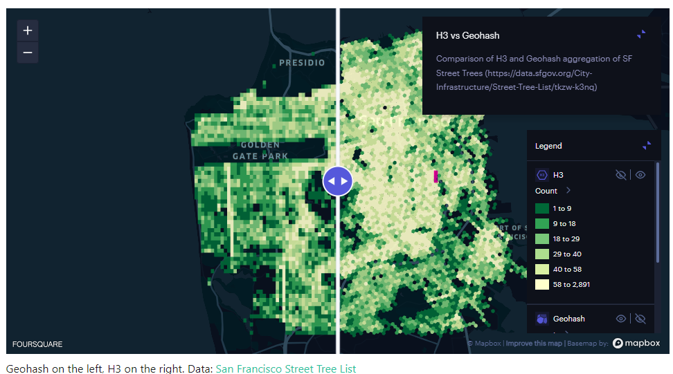
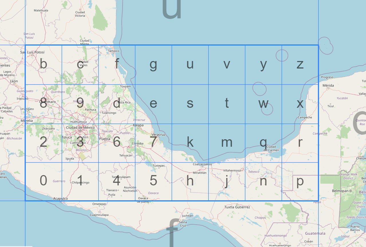
Geohash is a widely-used geocoding system that encodes geographic coordinates into a short string of letters and numbers. It divides the world into a grid of rectangles, each with a unique Geohash code. The longer the Geohash string, the more precise the location it represents.

H3: The Challenger

H3, on the other hand, is a relatively newer geospatial indexing system that’s gaining traction for its unique approach. Developed by ride-sharing company Uber, H3 uses a hexagonal grid to represent the Earth’s surface. Each hexagon is assigned a unique H3 index, offering a different perspective on geospatial indexing compared to Geohash.

Comparing Geohash and H3

We delve into the main differences between Geohash and H3 on a number of measures.

Precision

  • Geohash: Precision varies based on the length of the code. Longer codes are more precise, but this increases storage and complexity.
  • H3: H3 offers consistent precision regardless of location. Hexagons can be further subdivided for more precision, ensuring uniformity.

Spatial Relationships

  • Geohash: Geohash’s rectangular grid can struggle to represent spatial relationships accurately, especially near the poles (it should be noted that realistically, this is not going to be an issue in most use cases).
  • H3: H3’s hexagonal grid provides better spatial relationships, making it ideal for applications like ride-sharing services and navigation.

Support and Ease of Use

  • Geohash: Geohash is simple and widely adopted, making it easier to find resources and libraries for various programming languages.
  • H3: While H3 is gaining popularity, it may not have the same level of community support and resources as Geohash.

Applications

  • Geohash: Geohash is well-suited for applications that require basic geospatial indexing, such as location-based search or geofencing.
  • H3: H3 shines in complex applications like urban planning, logistics, and ride-sharing due to its consistent precision and better spatial relationships.

Scalability

  • Geohash: As Geohash codes get longer for more precision, storage and indexing can become inefficient.
  • H3: H3 scales more efficiently because it maintains uniform precision, regardless of location.
Geohash vs H3 Comparison

Source: H3

Geohash or H3: Choosing the right system

When it comes down to the choice between Geohash and H3, it really depends on your specific needs:

  • If you require a straightforward geospatial indexing system for basic applications, Geohash is a reliable choice with extensive community support.
  • On the other hand, if you’re dealing with complex spatial relationships, require consistent precision, or are working on innovative projects like urban planning or ride-sharing services, H3 offers a more promising solution. In the real estate context, it can be useful in urban planning, geofencing, spatial analysis, property market analysis.

Geospatial indexing is a fundamental technique used to manage and organise geographic or location-based data efficiently, in order to make data-based decisions or enhance applications.

Geohash is the old guard, tried and tested, while H3 is the newcomer with fresh ideas and uniform precision.

As we can see, both Geohash and H3 have their merits. However, the ultimate decision of which system to use should be based on the requirements of your project.

Snowflake releases H3 functionality

Snowflake provides SQL functions that enable you to use H3 with GEOGRAPHY objects.
This preview feature is now available to all accounts.

Read more from The Proptech Cloud

Useful Websites for Australian Properties, Parcels and Addresses

Researching the existence of a property or verifying data can be challenging, often resulting in conflicting answers. Depending on your definition of a property, it may be necessary to visit various websites to validate property data.

Understanding Housing Affordability: Key Metrics and Statistics

Housing affordability is a significant concern in many parts of the world, affecting the quality of life and economic wellbeing of individuals and families.

To understand the dynamics of housing affordability we need to take a detailed look at a range of different metrics and statistics to gain a full picture.

The Three Primary Methods of Real Estate Data Integration

cLearn the three primary methods of real estate data integration—geospatial relationships, title matches, and address matching—to improve accuracy, insights, and decision-making.

What’s the Difference Between GDA94 and GDA2020?

Geodetic datums, or geodetic systems, are often used by proptechs. Here is a rundown of everything you need to know about the different geodetic datums we use and reference in Australia.

Alternative Data: What Is It, Who Uses It And Why It Matters

Discover the powerful intel alternative data can offer. Learn why businesses and investors are turning to non-traditional data sources for deeper insights and smarter decisions.

Geohashes and Efficient Geospatial Joins in Snowflake

Geohashes and Efficient Geospatial Joins in Snowflake

Geohashes are an incredibly useful tool when it comes to spatial analysis. They serve as an encoding system that translates geographic coordinates into a short string of letters and digits, which simplifies and optimises geospatial operations.

One area where geohashes shine is in making geospatial joins more efficient. In this blog, we’ll dive into what geohashes are, and how you can leverage Snowflake’s ST_GEOHASH function to improve your geospatial joins in Snowflake.

What is a geohash?

A geohash is a hierarchical spatial data structure that subdivides space into a grid of cells, each cell having a unique string identifier. Geohashes convert a two-dimensional geographic coordinate (latitude and longitude) into this alphanumeric string. The length of the string determines the precision of the geohash; a longer string means a more precise location.

Read our blog on What is a Geohash for a detailed overview.

Geohash

How geohashes make geospatial joins more efficient

Geospatial joins can be computationally expensive because they often require pairing each record in one dataset with every record in another to calculate distances or find overlaps. This can lead to a computational complexity of O(N*M), which is not ideal for large datasets.

Geohashes simplify this problem by converting the geospatial coordinates into strings. When you want to join based on geographic proximity, you can simply perform a string comparison, which is far less computationally expensive than a full spatial join.

Snowflake and ST_GEOHASH

Snowflake offers native support for geospatial functions, including ST_GEOHASH. Below is a simple example of how you can use this function to create a geohash in Snowflake:

-- Create a geohash for a specific latitude and longitude
SELECT ST_GEOHASH(37.7749, -122.4194, 12) AS geohash;
In this example, 37.7749 is the latitude, -122.4194 is the longitude, and 12 is the precision of the geohash.

To perform a geospatial join using geohashes, you can do the following:

-- Create two tables with geospatial data
CREATE TABLE locations1 (id INT, latitude FLOAT, longitude FLOAT);
CREATE TABLE locations2 (id INT, latitude FLOAT, longitude FLOAT);

-- Populate tables (this is just a representation)
-- ...

-- Add a geohash column to both tables
ALTER TABLE locations1 ADD COLUMN geohash STRING;
ALTER TABLE locations2 ADD COLUMN geohash STRING;

-- Update the geohash columns using ST_GEOHASH
UPDATE locations1 SET geohash = ST_GEOHASH(latitude, longitude, 12);
UPDATE locations2 SET geohash = ST_GEOHASH(latitude, longitude, 12);

-- Perform the join using the geohash
SELECT a.*, b.*
FROM locations1 a, locations2 b
WHERE a.geohash = b.geohash;


Geohash – Streamlining geospatial joins

Geohashes offer a streamlined way to perform geospatial joins, drastically reducing the computational resources required. With native functions like ST_GEOHASH in Snowflake, it’s easier than ever to incorporate geohashes into your geospatial workflows. By leveraging the power of geohashes, you can perform complex geospatial analyses more efficiently, saving both time and money.

Read more from The Proptech Cloud

Useful Websites for Australian Properties, Parcels and Addresses

Researching the existence of a property or verifying data can be challenging, often resulting in conflicting answers. Depending on your definition of a property, it may be necessary to visit various websites to validate property data.

Understanding Housing Affordability: Key Metrics and Statistics

Housing affordability is a significant concern in many parts of the world, affecting the quality of life and economic wellbeing of individuals and families.

To understand the dynamics of housing affordability we need to take a detailed look at a range of different metrics and statistics to gain a full picture.

The Three Primary Methods of Real Estate Data Integration

cLearn the three primary methods of real estate data integration—geospatial relationships, title matches, and address matching—to improve accuracy, insights, and decision-making.

What’s the Difference Between GDA94 and GDA2020?

Geodetic datums, or geodetic systems, are often used by proptechs. Here is a rundown of everything you need to know about the different geodetic datums we use and reference in Australia.

Alternative Data: What Is It, Who Uses It And Why It Matters

Discover the powerful intel alternative data can offer. Learn why businesses and investors are turning to non-traditional data sources for deeper insights and smarter decisions.